
Blue Belt survey aboard RRS James Clark Ross
Cefas' James Bell reports on the March 2018 Tristan da Cunha Blue Belt survey aboard RRS James Clark
Blue Belt
The Blue Belt Programme is a four-year programme (2016 to 2020), delivered by the Centre for Environment, Fisheries and Aquaculture Science (Cefas) and the Marine Management Organisation (MMO) with the UK Overseas Territories on behalf of the Foreign and Commonwealth Office (FCO) and the Department for Environment, Food and Rural Affairs (Defra).
This programme will help to provide long term protection of over four million square kilometres of marine environment across the UK Overseas Territories.
Funded through the Conflict, Stability and Security Fund (CSSF) the programme will support the UK Overseas Territories develop, implement and enforce marine protection strategies. Research was carried out around the Tristan da Cunha and St Helena seamounts
My name is James Bell, I'm a fisheries and ecosystems scientist, based at the Centre for Environment, Fisheries and Aquaculture Science (Cefas), one of the UK organisations responsible for coordinating the work for the Blue Belt programme. I was recently part of a month-long research survey to a number of seamounts in two of the UK overseas territories, Tristan da Cunha and St Helena on the RRS James Clark Ross.
We began the voyage in the Falkland Islands in mid-March and spent eight days in each of Tristan da Cunha and St Helena. Many of the scientists stayed on St Helena after the survey, working with the local Government to further develop the projects.
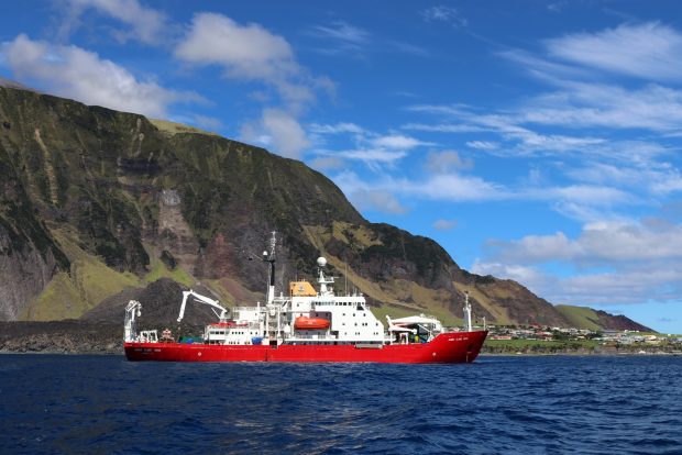
Photo from BAS' Rich Turner shopws the RRS James Clark Ross in front of Tristan Island.
Working with our partners to deliver the Blue Belt
This survey was primarily a joint effort between Cefas and the British Antarctic Survey, but involved scientists from several other institutions, including the RSPB, Plymouth University, the South Atlantic Environmental Research Institute and the UK Hydrographic Office. British Antarctic Survey, as part of its Official Development Assistance programme, are increasingly working with small island nations, like the OTs, to disperse its considerable expertise outside of the polar regions. Together with Blue Belt, this makes for a great alignment between BAS and Cefas scientists.
Addressing the scientific knowledge gaps
St Helena declared a sustainable use MPA across its 445,000km2 maritime area in 2016. Tristan da Cunha is currently collecting evidence and considering possible regimes for protecting the waters across its maritime zone of 750,000km2. This survey was designed to address gaps in the knowledge and understanding of the Tristan and St Helena marine territories, in support of decisions about how they plan to safeguard their marine environment and allow sustainable development into the future.
The marine environment here is the summation of all the different ecosystems within the Tristan da Cunha or St Helena maritime zones and building understanding is vital for taking an ecosystem approach to fisheries management. It is important for our projects to get as wide a view of this as possible so that we can consider the different links and how the implications of different management decisions might be felt elsewhere. This is also key for other uses of the marine environment (e.g. for tourism) and fishing certainly isn't the only thing to consider.
Three work themes
The survey was divided into three main work themes, with other projects (like surveying for plastic pollution) happening when time allowed. The key work areas were seabed mapping and the biodiversity of seafloor (benthic) and water column (pelagic) ecosystems. At Tristan da Cunha, where the fisheries are all at or near the seafloor, the main focus were the benthic ecosystems but for St Helena, where the main catches are tuna that largely inhabit the top 100 m of the oceans, the pelagic ecosystem component was the most important.
Seabed mapping
As a general rule, the vast majority of the deep ocean floor is mapped very poorly and Tristan and St Helena are no exception. In most areas, the resolution of the best available maps (which use data gathered by satellites that measure the strength of the Earth's gravitational field) is something in the order of about 1 kilometre squared. That's really coarse, and means that the map misses a great deal of information (it can even miss entire mountains if they are small enough). The James Clark Ross is equipped with a system called 'swath bathymetry' which acts very much like an echo sounder.
Pulses of sound are sent to the seafloor and the time taken for the sound to return relates to the depth of the seafloor under the ship. Depending on the depth, the resolution of the new map data was between 10 and 100 metres squared (that's between 100 - 10,000 times better than the satellite maps). Although time-consuming to collect, these maps are really valuable to the overseas territories as they provide a much better description of the kinds of habitats present, which also was critical to the benthic ecosystems component. Often, the distribution of different habitats is controlled by factors like depth, slope and how rough the topography is, and the refined maps we produced give us a far greater idea of this.
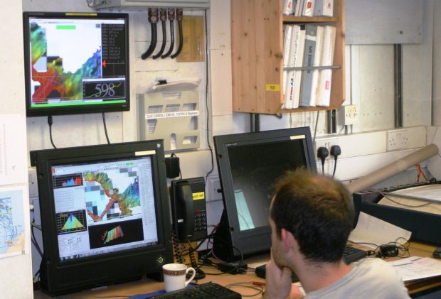
Photo from Vlad Laptikhovsky shows Cefas' UKHO mapping expert Dan Evans monitoring incoming data.
Seafloor habitats
Around seamounts and remote islands, seafloor ecosystems can often be very unique and biodiverse, which makes them important places to consider in terms of regional ecosystem management. The scientists on board James Clark Ross were working to understand the different types of ecosystems present at the Tristan and St Helena seamounts, and assess whether historic fishing has had any impacts on the species that inhabit these areas. Most of this work was conducted using a non-invasive camera lander system developed by BAS scientists but physical specimens were also collected using a small scientific trawl.
This trawl is specifically designed to cause a minimum of disturbance and is important for two reasons. Firstly, although the quality of the photos we took of the seafloor is very good, photos are almost never enough information on their own to get the identity of a species, and secondly, any additional studies (like for understanding food webs for instance) require specimens for the chemical analysis.
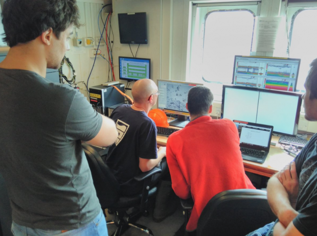
Photo from Nils Piechaud shows colleagues seeing first sight of the seafloor at one of the seamounts of Tristan da Cunha.
Open Ocean habitats
For many of the commercially important species in Tristan (e.g. bluenose warehou) and St Helena (e.g. yellowfin tuna), there are important prey species, like small fishes and squids (pictured), spread throughout the water column, from the surface to near the bottom. The distribution and quantities of these species is therefore of clear importance for determining the health and status of the commercial stocks. The scientists on James Clark Ross used a mid-water trawl net that opens and closes at different depths. This allowed them to take samples from different water depths, down to almost 1000 m at times and compare catches between different areas, both in terms of the species present and their abundance.
The team also used an echo sounder to look for dense shoals of these midwater species (mostly fish and squid) and by comparing these data to the catches in the nets, can start to get an idea of how much biomass is present at each seamount. Seamounts, because of the way they interrupt deep water currents and force nutrient-rich waters nearer the surface, often have much higher biomass than the surrounding deep water and this was true in Tristan and St Helena waters. This is important because it starts to tell us about which areas of their seas are important for the commercial species, and helps guide management decisions.
Extra work
On the James Clark Ross, the team worked 24hrs a day, which creates a lot of time to try and collect a wide range of samples. Further to the main work areas described above, there were a number of other projects. Two of the scientists spent most of their time on the bridge, collecting data on the sightings of seabirds and marine mammals.
Tristan da Cunha in particular is renowned for its seabird biodiversity, such as the Atlantic yellow-nosed albatross (pictured), and on some days, Andy Schofield (from RSPB) saw as much as twenty species before breakfast! Amongst the mammals spotted by Steph Martin, a marine mammal specialist, were sperm whales, orca and even a rare sighting of a beaked whale. These records are really important for understanding which species are present in the OT marine territories and because they are so remote, the data is usually very hard to collect.
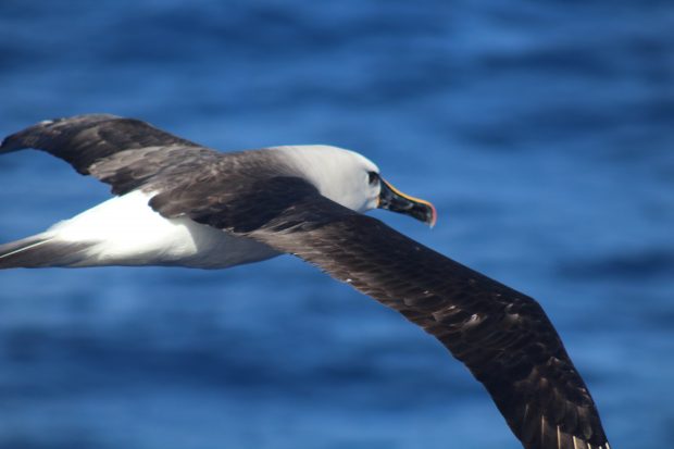
Photo from James Bell shows an Atlantic yellow-nosed albatross.
We also collected samples to analyse the amount of plastic pollution in St Helena waters, as well as deploying a near-surface baited drift camera around Tristan da Cunha to enhance records of the pelagic biodiversity. We were even able to make good use of the travel time and got busy analysing many of the samples from the Tristan da Cunha fishery, including some very smelly stomach contents!
Next steps
We were all very happy with the survey, even the weather was kind and on the whole, very little time was lost to technical problems (which can be a common thing on research ships). I'm very much looking forward to continuing working with the team as we get stuck into the shoreside element!
We will shortly get under way with analysing the samples we collected and Cefas, together with BAS, will use these data to provide advice to Tristan and St Helena Governments over the coming months and years, ahead of their marine protection strategy decisions in 2020. We will also use the lessons learnt on this survey to help us plan the follow up survey (on the RRS Discovery) scheduled for March next year.