
ATBA: Areas To Be Avoided in Tristan Waters
Introduction
As part of Tristan da Cunha's planning to create a 'Blue Belt' Marine Conservation Area in 2020, and to avoid shipwrecks like the MS Oliva in 2011, the Tristan da Cunha Government has created an ABTA - Areas To Be Avoided - area effective from April 2020. All vessels embarking on voyages close to the islands are asked to ensure they adhere to the 25 nautical mile exclusion zone for ships in transit above 400 tonnes as set out in the document below which is also available to download using the link below and at the foot of this page.
Downloadable PDF = ATBA For Tristan da Cunha
Government of Tristan da Cunha
Establishment of Recommended Areas to Be Avoided (ATBA)
Tristan da Cunha
Summary
This document contains the details for the establishment of recommended Areas To Be Avoided (ATBA) around islands in the Tristan da Cunha archipelago by vessels making transoceanic voyages. The areas are designed to reduce the possibility of incidents by increasing the safety of navigation and additionally to protect the marine environment in the region.
The remoteness and meteorological conditions pose significant challenges to any response to any incidents and possible resulting pollution. The economic reliance of the local community on the fisheries and high environmental sensitivity means this is a high-risk region for hazards from international shipping.
The ATBAs are designed to decrease the impacts of international shipping in these areas and are located within the limits of the Tristan da Cunha EEZ. The 25 nautical mile buffer provides
- a safe distance between international shipping and the shoreline
- reduces the risk of shipping incidents and accidents
- allows time to mount a response to a developing marine emergency due to negligent navigation
- protects the sensitive environment
The ATBAs apply to ships 400 gross tonnage and above solely in transit.
Description
Tristan da Cunha Group
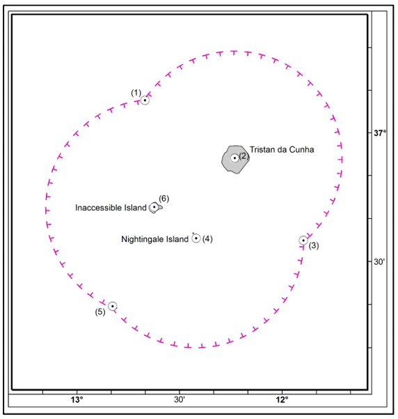
An Area To Be Avoided, by all ships 400 gross tonnage and above solely in transit, with a radius 25 nautical miles, is centred on the following geographical position:
Tristan da Cunha
37° 06′·714 S 12° 17′·330 W (Queen Mary’s Peak)
Nightingale Island
37° 25′·424 S 12° 28′·652 W (High Peak)
Inaccessible Island
37° 18′·125 S 12° 40′·888 W (approximate centre of island)
Consolidated ATBA Limit
An area bounded as follows:
|
Starting at |
(1) |
36° 53’·187 S |
12° 43’·590 W |
|
then an arc with a radius 25 nautical miles centred at |
(2) |
37° 06′·714 S |
12° 17′·330 W |
|
to a point |
(3) |
37° 25’·939 S |
11° 57’·272 W |
|
then an arc with a radius 25 nautical miles centred at |
(4) |
37° 25′·424 S |
12° 28′·652 W |
|
to a point |
(5) |
37° 41’·199 S |
12° 53’·061 W |
|
then an arc with a radius 25 nautical miles centred at |
(6) |
37° 18′·125 S |
12° 40′·888 W |
|
to a point |
(1) |
36° 53’·187 S |
12° 43’·590 W |
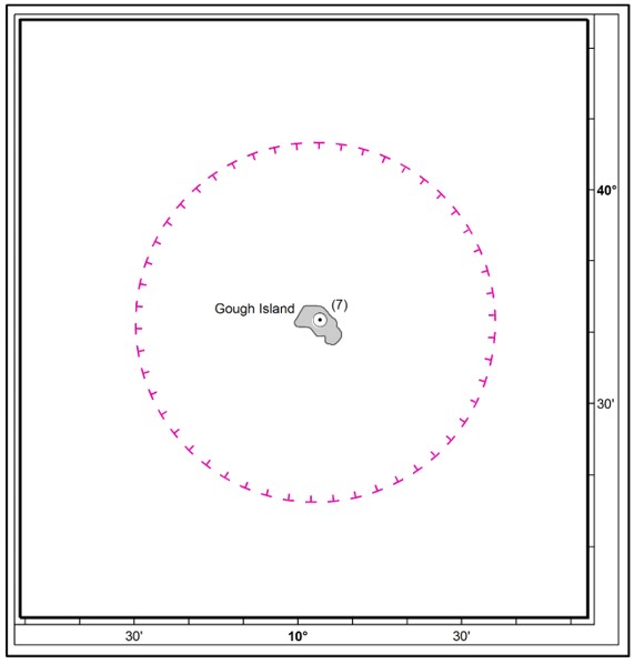
Gough Island
An Area To Be Avoided, by all ships 400 gross tonnage and above solely in transit, with a radius 25 nautical miles, is centred on the following geographical position:
40° 18′·555 S 9° 56′·817 W (7) (Edinburgh Peak)
Implementation Date: 1 April 2020
Reference chart: British Admiralty 4206, Edition 6 9th November 2017
Note: This chart is based on World Geodetic System 1984 datum (WGS 84)
“Tristan da Cunha” means the Island of Tristan da Cunha, Gough Island, Nightingale Island and Inaccessible Island.