70th Anniversary of the Gough Island Scientific Survey, 1955-56
Issue date: 13th November 2025
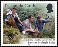 |
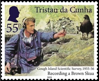 |
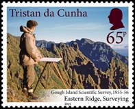 |
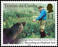 |
 |
 |
| Mint Stamps (2 x 55p, 65p, £1.00, 2 x £1.50) and First Day Cover | Shop > |
|
The Gough Island Scientific Survey was John Heaney's brainchild, planned during his final year as an engineering student at Cambridge. He had been a surveyor on South Georgia in 1951-52 and Gough Island, uninhabited and unmapped, was suggested as a goal by Dr Brian Roberts of the Scott Polar Research Institute. The expedition was to map the island, record its rocks and plant and animal life and test its value as a weather station. So a professional team was needed and Heaney chose several contemporary Cambridge graduates. Roger LeMaitre came as geologist, Michael Swales as ornithologist and seal biologist and Martin Holdgate as invertebrate zoologist. Botany was covered by the only Oxford member, Nigel Wace. Robert Chambers - a non-scientist but expert mountaineer - was to be assistant surveyor (and deputy Leader). Philip Mullock - a mathematician and keen radio amateur - was to handle the telecommunications and keep the party in touch with the outside world. All were under 30. The South African Weather Bureau, which already maintained a station on Tristan da Cunha, 230 miles away from Gough, agreed to second Johannes van der Merwe as meteorologist.
The planning was relatively straightforward, but gathering the funds was a test, for Government support was not available (although the Royal Navy offered transport from South Africa to Tristan). Thanks to several professional institutions and the generosity of companies and individuals - not least HRH the Duke of Edinburgh - the funds and equipment were gathered and travel provided. But there were upsets. Three months before the planned departure a medical problem forced John Heaney himself to step aside. Robert Chambers became leader and surveyor and James Hall, former naval officer and medical student, joined as cine-photographer. The party arrived at Tristan da Cunha early in October 1955 and stayed there for six weeks because - another hiccup - the fishing ship Tristania that was to take them to Gough was delayed with engine trouble. But the opportunities on Tristan were put to good scientific use - and links established with the islanders that were to last lifetimes.
On the 13th November 1955, the expedition, supported by two senior Tristan Islanders, Arthur Rogers and John Lavarello, finally landed on Gough, on the stony eastern beach where the Glen, largest of the island valleys, meets the sea. And - another set-back - in that landing, leader Robert Chambers injured his back. Three days later he was evacuated to Tristan, leaving Martin Holdgate to stand in as the third GISS leader. But the routine of getting established went smoothly: the sectional wooden hut was assembled, the generator and radios installed, and exploring parties began to climb the hills, sample plant and animal life, and count and make notes on birds and seals.
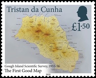
Those early forays showed that the existing maps were very inaccurate. Happily, soon after Christmas there was good news: John Heaney had been passed fit and was preparing to join the expedition! He arrived in early February 1956 bringing two young Tristan Islanders, Harold Green and Ernest Repetto, to replace Arthur Rogers and John Lavarello who had gone home at Christmas. With Heaney's professional skill, the survey moved swiftly and by the time the South African frigate Transvaal relieved the expedition on the 13th May 1956 the first good map of the island (later printed by the Royal Geographical Society) was complete; the rock structure had been documented and a comprehensive series of rock samples gathered; the vegetation had been described; a number of new plant species and invertebrate animals had been collected; the birds, including the bunting and flightless moorhen that occur nowhere else in the world, documented; and the fur seals and elephant seals counted. It was clear that the fur seals - unexpectedly shown to be a subantarctic species rather than the one found in South Africa - had recovered from the near extermination wrought by sealers in the 18th and 19th centuries and it was also clear that Gough Island was the most important seabird island in the entire southern cool temperate zone. It had also been established that weather observations on Gough Island would indeed be useful in improving forecasting in South Africa, so the South African Weather Bureau proceeded to lease the site for a weather station - initially based on the GISS wooden hut but later to be transferred to a better observational site on the wider area of level lowland at the south end of the island. All in all, the GISS had achieved everything its planners and supporters had hoped for, and from then onwards the island has remained an important scientific facility as well as justified its designation as a World Heritage site.
Description of the Stamps
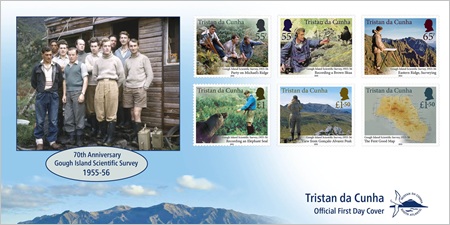
55p - Exploring party on Michael's Ridge on way to upland camp. Harold Green carries survey tripod: Martin Holdgate takes a bearing and Nigel Wace points to a feature of interest.
55p - Michael Swales prepares to record sounds of a Brown Skua.
65p - John Heaney with plane table, looks across the rugged eastern side of Gough Island.
£1.00 - Michael Swales records the throaty bellow of an elephant seal.
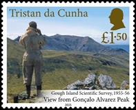
£1.50 - Roger LeMaitre looks across the uplands of Gough Island from the slopes of Gonçalo Alvarez Peak (formerly Expedition Peak) to Mount Rowett.
£1.50 - The map of Gough Island surveyed by John Heaney and published by the Royal Geographical Society.
FDC - GISS members outside the expedition base hut. From left: Harold Green; Ernest Repetto; Roger LeMaitre; John Heaney; James Hall; Philip Mullock; Nigel Wace; Johannes van der Merwe; Michael Swales; Martin Holdgate.
We acknowledge with thanks the help and assistance of Martin Holdgate.
Technical Specifications
| Photography: | Gough Island Scientific Survey members | Map photo: | David Holgate |
| Designs: | Bee Design | Printer: | Cartor |
| Process: | Stochastic lithography | Sheet format: | 10 |
| Stamp size: | 38 x 30.6mm | Perforation: | 13¼ x 13 per 2cm |
| Production Co-ordination: | Creative Direction (Worldwide) Ltd |
