 |
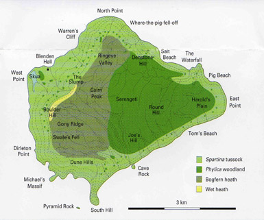
Inaccessible IslandInaccessible is an extinct volcanic island which was active 6 million years ago. Its central area is a dissected plateau reaching 449 metres above sea level at the summit of Cairn Peak. It is fringed with sheer sea cliffs and only a few boulder beaches, which made generations of sailors wary of difficult landings and inhospitable terrain. It was the modest Captain d'Etchevery, of the French ship Etoile du Matin, who, when he failed to land on the island in 1778, coined the name 'Inaccessible' rather than 'Ile de Etchevery', for which we are eternally grateful. In 2004 Inaccessible Island became a World Heritage Site in recognition of its importance as a wilderness of international significance, particularly for its rare land and sea bird species. It is known as the 'Gough and Inaccessible Islands World Heritage Site'. |
 |
Inaccessible at sunsetViewed from North Landing on Nightingale Island, Inaccessible's south-east outline is silhouetted against the evening sky, with two crawfishing boats (probably Tristania II and Hekla) enjoying the calm summer weather. |
Approaching from Tristan
|
Blenden Hall
This area has since always been called 'Blenden Hall' and was the site for the hut built by the 1982/3 Denstone College Expedition to Inaccessible . This photograph taken in December 1982 shows the Denstone Expedition departing for a Tristan Christmas break. There is still only one hut on the island (2019). |
Sheer Cliffs
|
 |
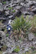
Conservation in ActionLeft : Lourence Chiloane, protected by a rope on the 230 metre sheer cliffs behind Waterfall Beach, is removing a large flax plant as part of a 2004/5 project to remove alien plants from the World Heritage Site. A full report of the conservation work with five colour photographs was published in the March 2005 Tristan da Cunha Newsletter. Back numbers are available to new Tristan Association members. Link to Membership Page Photo from team leader Peter Ryan. |
 |
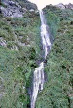
The WaterfallRight : The Waterfall plunges some 230 metres down the sheer north-east cliffs. Unlike most Tristan gulches, Waterfall Gulch always flows, as its source (near the summit of the 388 metre high Round Hill), is peat bog which retains water during dry periods. |

 Inaccessible's north-east coast is 40 kilometres (25 miles) from Longbluff on Tristan's south-west coast. This view is from about 10 kilometres away, showing the sheer cliffs which give the island its forbidding name. Visible straight ahead is Salt Beach, where the German Stoltenhoff brothers attempted to colonise the island between 1871-3. Rev Wilde organised a '5-year' farming project at Salt Beach which failed to live up to its aims and was abandoned after he left Tristan in 1940, but islanders still occasionally visit to pick the apples planted in the 1930s.
 The Tristan Islands' most famous shipwreck was that of the 450 ton East Indiaman Blenden Hall, which was destroyed on 23rd July 1821 after running ashore in a heavy swell in otherwise calm but foggy weather. Some 50 survivors existed through the southern winter by living off fish, sea birds and penguins before reaching Tristan on a make-shift salvaged boat. Islanders ferried the remaining survivors to Tristan where they remained until January 1822.
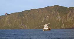
 This picture is taken from the deck of the SA Agulhas in 2004 by Brian Rogers shows MV Kelso during crawfishing operations and the Agulhas helicopter in flight during operations to support a conservation group based on the island.